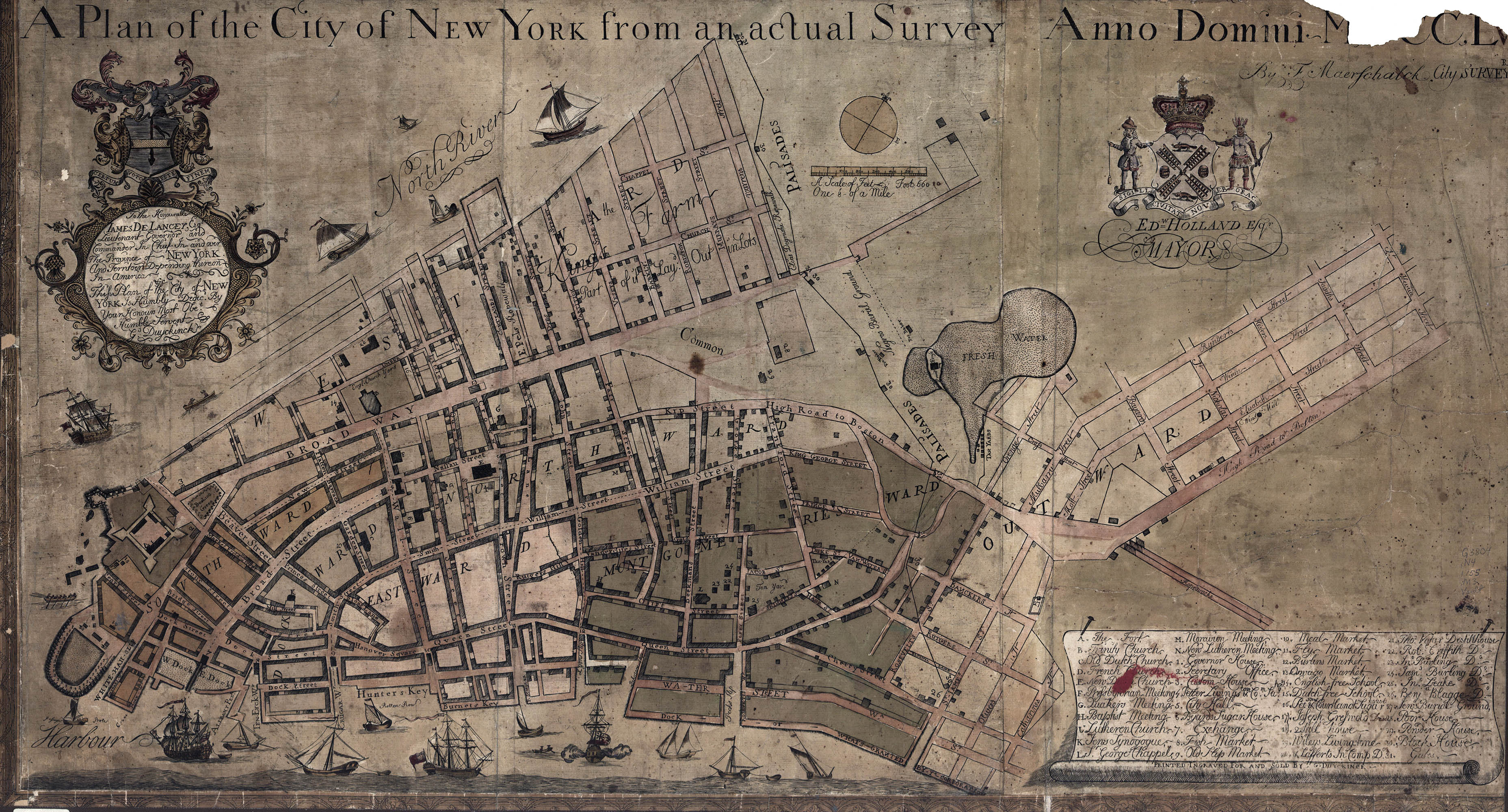
The Maerschalck Map
A Plan of the City of New York from an Actual Survey, Anno Domini MDCC,LV
Francis Maerschalck/Geraldus Duyckinck, 1755
The French and Indian Wars kept the city on constant vigil – the Common Council even erected a log palisade in 1745 to protect against French raiding parties.1 Mostly, however, the conflict was welcomed by the merchant class. As Benjamin Franklin wrote "New York is growing immensely rich, by money brought into it from all Quarters for the Pay and Subsistance of the troops."
This economic boon also brought an increase in population: from some 12-13,000 by 1750 to nearly 18,000 by 1760 (second to only Philadelphia). There were 1991 houses in 1753 and 2600 in 1760.
The Swedish botanist Pehr Kalm described the city in 1749:
"The streets do not run straight as those in Philadelphia and have sometimes considerable bendings; however they are very spacious and well-built, and most of them are paved, except in high places, where it has been found useless. In the cheif streets there are trees planted, which in the summer give them a fine appearance, and during the excessive heat at that time afford a cooling shade.”
“Most of the houses are built of bricks; and are generally strong and neat, and several stories high. Many of the houses had a balcony on the roof, on which the people used to sit in the evenings in the summer season; and from thence they had a pleasant view of a great part of the town, and likewise a part of the adjacent water and of the opposite shore." 2
Francis Maerschalck (? – 1776) was appointed as the city surveyor by the Common Council in 1733 and had a long and productive career, being responsable for most of the major surveying in the city until the Revolutionary War. Among other things he surveyed the boundary between the city and Harlem in 1749 and Bloomindale Road in 1760.
The map, a 17 x 33" copperplate engraving, was conceived as an entirely commercial venture between Maerschalck and the publisher Geraldus Duyckinck. If it looks suspiciously similar to the Bradford map it was because they actually used his plate for the left half and prepared a new plate for the right half. Duyckinck first advertised it in the 3 Mar 1755 New-York Gazette.
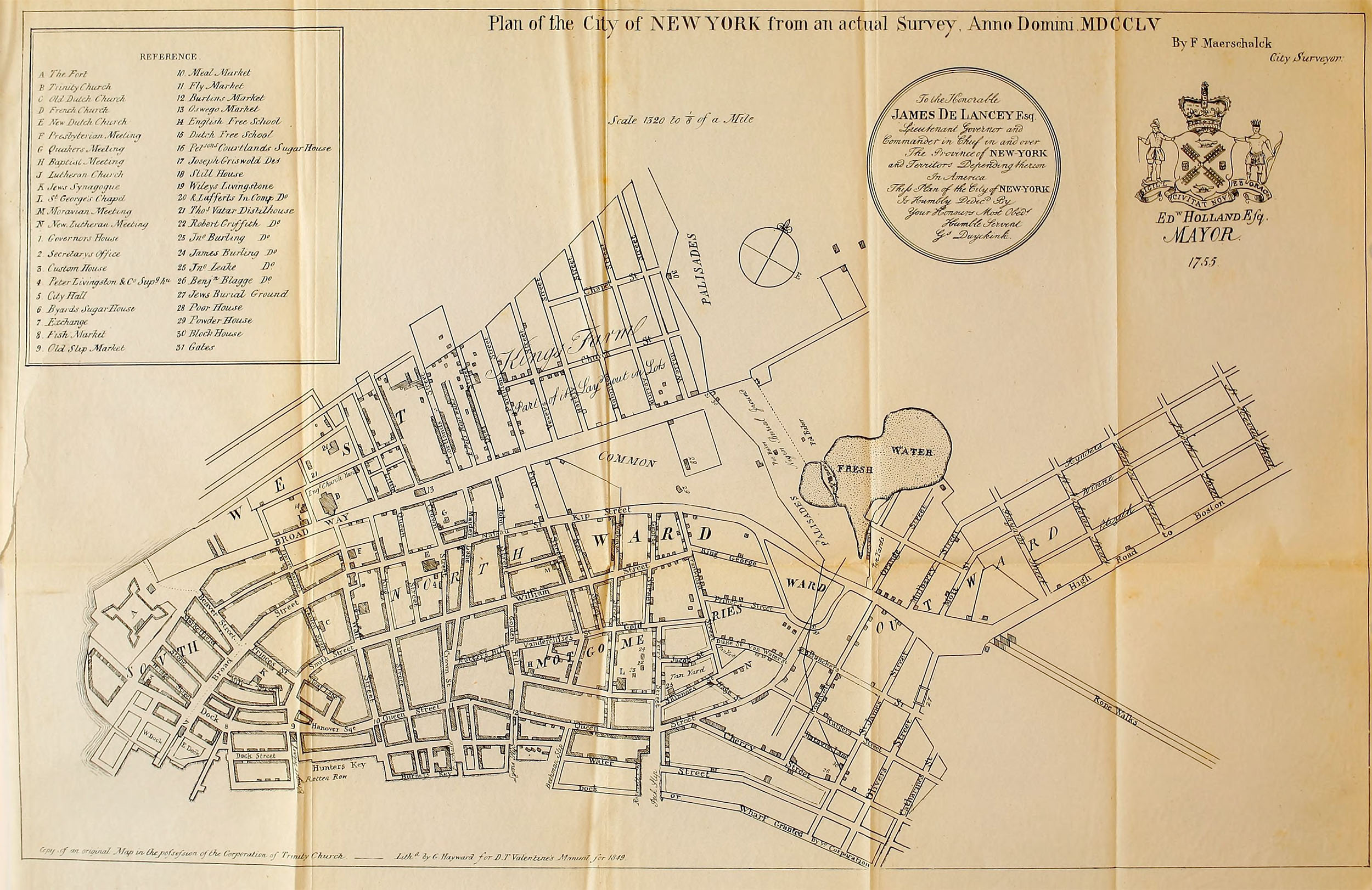
The map was noted even in its’ day as being rare and the copy above, from the Library of Congress, is one of only a few still in existence.3 Nevertheless it has been reproduced several times, including in the 1849 Valentine’s Manual: 4
The map shows the area covered by the Bradford map (albeit with many corrections and changes), as well as new development to the north [present-day World Trade Center], and the east [present-day Little Italy]. The map also shows the first systematic land-use development – an idea that would eventually result in the Randel plan.
7 July 2015
1. For an account of the war see: Eckert, Allen. Wilderness Empire: A Narrative. Boston: Little, Brown, 1969 (WorldCat).
2. Kalm, Pehr. Travels into North America (2 vol). London: T. Townes, 1773 (online).
3. Library of Congress G3804.N4 1755 .M3
4. Valentine, D.T. (ed). Manual of the Corporation of New York. New York: McSpedon & Baker, 1849 (online).