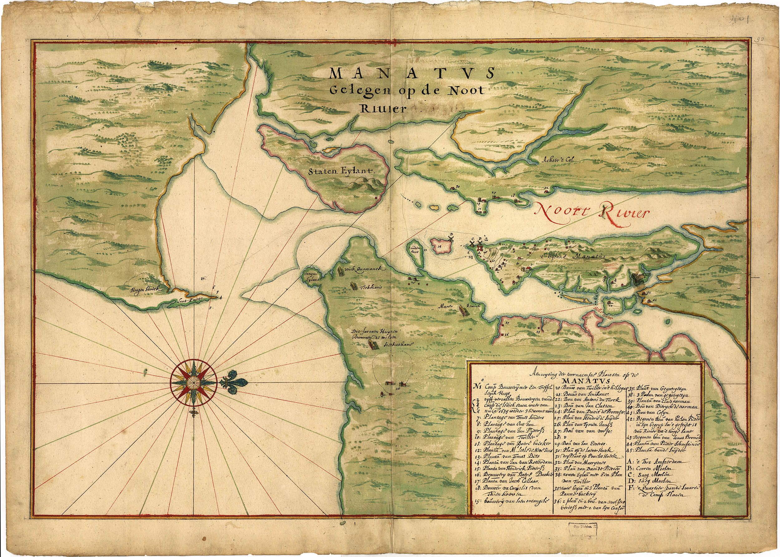
The Manatus Map
Manatvs Gelegen op de Noot (sic) Riuier
(Manhattan Lying on the North River)
Anonymous, ca.1665
Initially the West India Company had some difficulties attracting settlers to New Netherland. Their first idea to change this was patroonships. The Charter of Privileges and Exemptions of 1629 granted land rights to company members who “shall forever own and possess and hold from the Company as a perpetual fief of inheritance, all the land lying within the aforesaid limits.” In exchange the patroon would provide settlers, erect buildings, prepare farms, and of course, negotiate with the native population.1
Although several patroonships were formed, only Killian Van Rensselaer’s 700,000 acre Rensselaerswyck [near present-day Albany] was successful.2

Renselaerswyck, ca.1632. Wikimedia Commons
Later efforts would prove more useful: In 1638 the Dutch States-General signed the Articles and Conditions, abolishing the WIC monopoly over trade and in 1640 the Freedoms and Exemptions, allowing any citizen of the colony to own land.
With these property and commerce rights trade in the colony flourished, both with merchants back home in the Netherlands and with the surrounding English and Swedish colonies. The population rose from some 300 in 1628 to 500 in 1640 to 2500 in 1645 to perhaps as many as 9000 in 1664.
After the 1638 Articles and Conditions were adopted the WIC commissioned a survey of the colony, possibly by the surveyor/farmer Andries Huddle, to show the various land concessions and perhaps secondarily to promote additional settlement. The original survey, now lost to the mists of time, was reproduced three times in the mid 1660s. The map above, a 26 × 17" ink and watercolor wash on paper manuscript, was eventually acquired by the Dutch cartographic firm Gerard Hulst van Keulen. The expatriate historian Henry Harrisse bought the map in 1887 and bequethed it to the Library of Congess in 1915, hence its designation as “the Harrisse copy.” 3,4
Harrisse thought the map was drawn by Johannes Vingboons, but later historians such as I. N. Stokes or Richard Stephenson consider that unlikely.
The map shows 45 seperate houses or farms and their owners. In some cases it even includes property lines. Also of note are Fort Amsterdam (but not the extent of the settlement), Lenape encampments on Long Lsland and slave quarters. The key is covered in detail in Stokes’ Iconography.5 It is the first true map of Manhattan island.
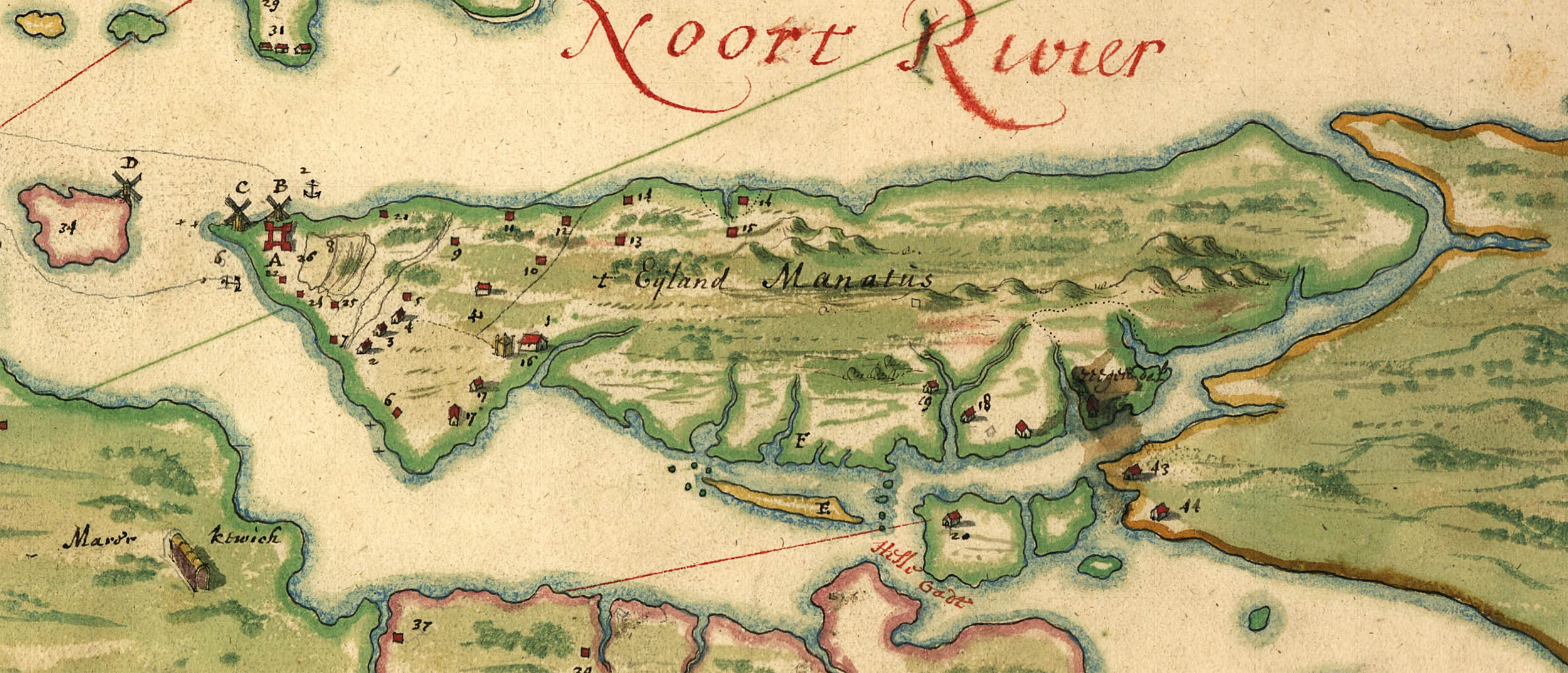
Detail, Manhattan Island
15 December 2013
1. See: Oliver A. Rink. Holland on the Hudson: An Economic and Social History of Dutch New York. Ithaca, NY: Cornell University Press, 1986 (WorldCat).
2. For more on Renselearswyck see: Van Laer, A. J. (ed).Van Rensselaer Bowier Manuscripts. Albany, NY: University of the State of New York, 1908 (online).
3. For more historical background see: Dunn, Shirley. “Interpreting the Little-Known Minuit Maps of c.1630.” The Hudson Valley Regional Review. 1992; 9: 26–38 (online).
4. Library of Congesss G3291.S12 coll.H3
5. Stokes, I. N. Phelps. The Iconography of Manhattan Island, 1498–1909. New York: Robert Dodd, 1915–1928. (6 vol) (online).
The Manatus Map: v2, 181–208